| Llanafan, a Common & The River Chwefru |
 1: Llanafan Church - Chwefru footbridge (15 mins) 1: Llanafan Church - Chwefru footbridge (15 mins)
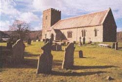
Llanafan, a huge parish, was an important monastic centre. The empty hills between here and Llanwrthwl were once well populated. Much evidence of hut circles and stock enclosures reveal busy times in the Bronze and Iron Ages: the Romans had their work cut out subduing these hills. The Red Lion pub has stood here for a thousand years.
In the field to its left is an ancient burial mound. The area has several impressive standing stones - one is on our walk.
Set in the wall of the church porch are three pre- Christian sacred stones. The yew may be even older. Take the grassy path out of the churchyard and go by road downhill, crossing a bridge over a stream. The first gate on the left brings us to the banks of the Chwefru and a footbridge.
2: Chwefru footbridge - the Common (15 mins)
Cross the bridge and take the track, right, up the hill. At the bend the path continues straight on, passing through woods. It then follows the fenceline, one field back from the river, making a bee-line for the common. Beneath the steep escarpment of the Common runs a stream.
3: Onto Comin-y-garth 10mins
Cross the stream where you can. The boundary fence we’ve been following ends across the stream. It is from this point the path up the escarpment starts, taking a slight diagonal left. At the top turn right.
4: Comin-y-garth (time to absorb it all)
Walk along the escarpment edge to the highest rocky outcrop.
The commons once extended from the mountains to Newbridge-on- Wye. Scattered remnants are linked by the surviving network of green lanes which this walk dips into. The lower common is Comin Coch, the higher, Comin-y-garth. As we find in the many ‘garths’ of the district, this naturally defensive position once supported an enclosure. Looking north, the wild hill to the right of the church is a spur of the Cambrians beneath which flows the Chwefru. The end, Allt Clych, looks rounded from this angle, but from most other angles appears pointed and a feature of the Cambrian skyline. Further right, a TV mast sits atop the hills from which the Wye leaves the mountains of its birth. Right of them we look beyond Llandrindod Wells into north-west Radnorshire. Next on the horizon, massive Radnor Forest, as high as the Cambrians. Then come Gilwern Hill and Carneddau (Walk 3), above Builth Wells. Here the Wye is squeezed between the next two hills in our view, Aberedw and Pant-yllyn (Walk 2). The long ridge next is where Moelfre and Mynydd Epynt make the far wall of the Irfon Valley and the watershed of the Wye and Usk rivers. Continue along the ridge towards the river and cross over the stile.
5: The Common - The River (50 mins)
Follow the fenceline downhill to a gate. We go left, through it. (The footbridge, beyond, leads to the road - a good mile to return to the start.)
Follow the fenceline to the second gate on the left. Through it, continuing in the same direction, through another gate, until we are walking on the remnants of a tree-lined green lane. Nice to linger by the river here. When coming to a junction of gates, carry straight on - the shape of the old lane is very clear now. We come to a Y junction of green lanes. Turn right for the river. Beneath the tree clad banks is another nice place to linger. (This footbridge crosses to a long lane which leads to the road - 2 miles to return to the church this way). Or:
6: The River - The Common (50 mins)
Return to the Y junction; return along the stretch leading to the junction of gates, but just before them notice, on the right, within a triangle of hedges, some marshy ground.
In fact this is a funnel into another green lane - more of this fascinating network. We take it as far as the farmyard of Afallenchwerw (it takes its name from the river). Take the gate on the left, just before the barns, crossing the field to Llwyn-garth-fawr. In front of the house turn right and go down the drive as far as the common. On the open common turn left and make for the escarpment once again.
7: Descending the Escarpment (10 mins)
Either go down by the path we came up, or take the long diagonal path down leading left off it - it can be indistinct.
|
|
| Submitted By: |
Builth & District Matters Ltd |
| Address: |
The Strand Hall, Builth Wells, Powys LD2 3AA |
|
|
|